Digital mapping has become indispensable for infrastructure planning, maintenance, and safety. The intricate network of subsurface infrastructure—including water, gas, electric, and telecommunications lines—requires precise and reliable mapping tools. UtiliSource uses digital mapping to improve project outcomes, prevent costly errors, and enhance operational efficiency.
This article explores the essentials of mapping underground utilities and highlights the role of geographic information systems (GIS) in transforming how project managers and facility managers approach underground utility mapping.
The Importance of Digital Mapping in Utility Management
Digital mapping is the process of creating, storing, and utilizing digital representations of real-world locations and infrastructures. For utilities, this involves the accurate mapping of underground utilities such as gas pipelines, water lines, and telecommunications lines. Given that traditional mapping methods are often outdated or incomplete, digital mapping offers a far more accurate and interactive way to locate and document utility data.
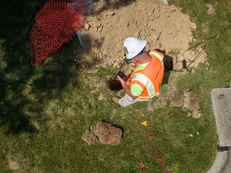
By mapping underground utilities in real time, project managers and utility locators gain a clear view of the subsurface infrastructure, significantly reducing the risk of accidental line strikes or disruptions during excavation and maintenance projects. With reliable data on hand, managers can ensure that projects proceed smoothly, with minimal disruptions to the surrounding community.
Geographic Information Systems (GIS): The Backbone of Utility Mapping
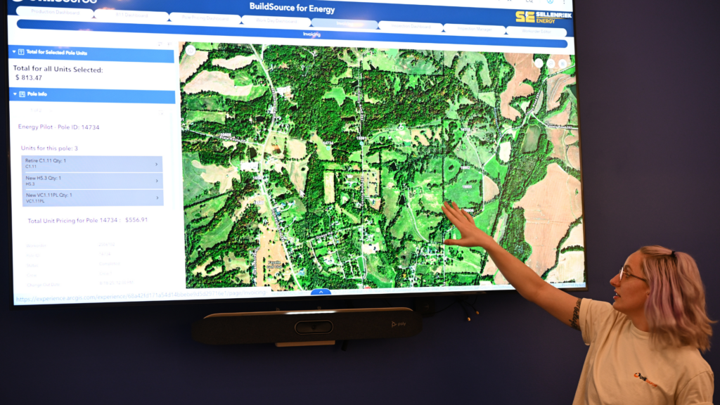
Geographic Information Systems (GIS) are crucial in creating and managing utility maps. GIS platforms integrate diverse data sources, from satellite imagery to electromagnetic (EM) locators, allowing utility locators to access comprehensive, real-time data on underground infrastructure. For utility companies, GIS serves as a centralized source of truth, providing project managers and facility managers with accurate, up-to-date information on the location of underground utilities.
GIS technology also enhances interactive maps, enabling utility professionals to visualize subsurface infrastructure layers and make data-driven decisions about locating and mapping utilities. Whether mapping a new development area or updating records for an established infrastructure network, GIS ensures that utility data remains precise and accessible for future use.
Mapping Underground Utilities: Tools and Techniques
To accurately map underground infrastructure, utility locators rely on several tools and techniques, each suited to different types of infrastructure. Here’s a closer look at the tools commonly used in underground utility mapping:
- Electromagnetic (EM) Locators
EM locators are essential for detecting metallic utilities, such as water lines and gas pipes. These devices send an electromagnetic signal through the ground, which reflects off conductive materials, enabling utility locators to accurately pinpoint utility locations without excavation. EM locators are particularly valuable for mapping telecommunications lines and other critical infrastructure that lies beneath the surface. - Satellite Imagery and Remote Sensing
Satellite imagery enhances utility mapping by providing a broad view of the terrain, allowing utility companies to monitor changes over time. High-resolution satellite imagery assists in planning infrastructure projects by offering insights into potential environmental impacts, optimal pipeline routes, and more. - 3D Mapping and Interactive Maps
Many utility companies now use 3D mapping and interactive maps to visualize underground infrastructure. These advanced maps offer an intuitive interface that allows users to toggle between various infrastructure layers. Interactive maps give utility locators, project managers, and facility managers a more comprehensive understanding of subsurface utilities, improving project planning and safety.
The Benefits of Locating and Mapping Underground Utilities
Accurate underground utility mapping provides several advantages for project managers and facility managers. Here are some key benefits:
- Enhanced Safety: Real-time data on underground utilities minimizes the risk of line strikes and accidents during excavation. By accurately mapping the location of underground utilities, project managers can reduce risks to both workers and the public.
- Increased Efficiency: With clear data on subsurface infrastructure, utility locators can perform their tasks more efficiently, reducing project delays and associated costs. Digital mapping allows for faster and more accurate project execution.
- Improved Planning and Maintenance: Comprehensive mapping of underground utilities supports better planning for both new construction and ongoing maintenance. Facility managers can access up-to-date utility data to make informed decisions about scheduling repairs, upgrading infrastructure, or expanding utility networks.
- Cost Savings: Avoiding accidental line strikes prevents costly repairs and project delays, leading to substantial cost savings for utility companies and project managers. Accurate mapping is a proactive approach that saves money in the long run by reducing unplanned expenses.
Applications of Underground Utility Mapping Across Industries
Mapping underground utilities is not only vital for utility companies; it’s also beneficial across various industries, including construction, telecommunications, and water management. Here are some examples of how different industries utilize underground utility mapping:
- Telecommunications: Accurate mapping of telecommunications lines is critical for the expansion and maintenance of communication networks. By knowing the exact location of existing lines, telecom companies can plan new projects with minimal disruption to current services.
- Water and Wastewater Management: Mapping underground water lines helps ensure safe and efficient maintenance of municipal water systems. Facility managers use this data to plan repairs and prevent leaks, safeguarding essential water resources.
- Construction: In the construction industry, precise utility mapping is crucial for avoiding line strikes and maintaining project timelines. By using interactive maps and real-time data, construction project managers can reduce the risk of damaging underground infrastructure.
Real-Time Utility Mapping and the Future of Infrastructure Management
The future of underground utility mapping lies in real-time data integration and the development of more sophisticated digital tools. By combining GIS with real-time data from satellite imagery, EM locators, and GPR, utility companies can create a comprehensive, up-to-the-minute view of subsurface infrastructure.
As more cities adopt smart infrastructure, the demand for accurate underground utility mapping will only increase. Future advancements in utility mapping will likely include enhanced integration with IoT devices, automated data collection, and the development of predictive maintenance tools. These innovations promise to improve utility management, making it safer, more efficient, and better suited to meet the demands of modern infrastructure.
Conclusion: The Role of Digital Mapping in Utility Management
Digital mapping has revolutionized the way utility companies manage and maintain subsurface infrastructure. From mapping underground utilities to providing real-time data for project managers and facility managers, digital mapping tools are essential for the effective and safe operation of utility networks. As technology continues to advance, the integration of GIS, EM locators, satellite imagery, and interactive maps will further enhance utility mapping capabilities.
Accurate and efficient mapping is the foundation of successful infrastructure projects. By leveraging these technologies, utility companies can ensure safer operations, streamline project management, and achieve significant cost savings. As digital mapping tools evolve, they will play an even more critical role in shaping the future of utility management.